Package 1
Package description
The options included in this package are:
- Active Communities;
- Bus Priority Measures;
- Improved Public Transport Passenger Interchange Facilities
- Investment in Demand Responsive Transport (DRT) and Mobility as a Service (MaaS);
- Linespeed, Passenger and Freight Capacity Improvements on the Aberdeen to Inverness Rail Line;
- Bypasses of Forres, Elgin, Keith and Inverurie; and
- A96 Electric Corridor
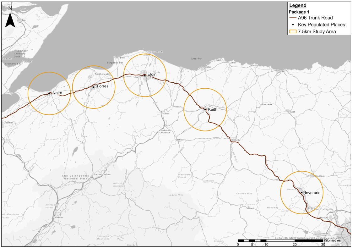
This package is focused on primarily delivering transport network improvements to specific towns along the A96 corridor, namely Nairn, Forres, Elgin, Keith and Inverurie, by providing enhancements which would aim to encourage a shift to sustainable modes, increasing opportunities for residents and businesses and improving road safety. It should be noted that the A96 Dualling Inverness to Nairn (including Nairn Bypass) scheme does not form part of the A96 Corridor Review as it has successfully progressed through a Public Local Inquiry and has Ministerial consent. Interventions within Nairn itself, similar to those proposed within the other bypassed towns, however, have been included in this package for appraisal.
This package focuses on delivering networks of high quality active travel routes and facilitates placemaking improvements within the settlements of Nairn, Forres, Elgin, Keith and Inverurie, by creating ‘Active Communities’, where more space would be provided for people rather than traffic, which could reduce the need to travel unsustainably. Active Communities draws from the ‘20-minute neighbourhood’ concept (10 minutes there, 10 minutes back) and is built around an approximate radius of 800m from the centre of each town, whilst also creating safer routes to school and encouraging more inclusive environments for people walking, wheeling and cycling. This would enhance the sense of place and encourage the local communities to spend more time within their local areas.
This package also aims to improve the safety, resilience and reliability of the A96 Trunk Road through the provision of a bypass at Forres, Elgin, Keith and Inverurie, whilst also addressing real and perceived severance within these communities by removing through trips. This element of the package is seen as a key enabler to maximising the benefits associated with Active Communities. As noted above, the provision of a bypass at Nairn is not included within this package as it forms part of the A96 Dualling Inverness to Nairn (including Nairn Bypass) scheme.
A number of public transport interventions targeted at delivering faster and more reliable journey times as well as improving the overall passenger experience also form part of this package. Journey time and reliability improvements would be achieved through the inclusion of bus priority measures at appropriate locations, with rail improvements delivered through linespeed and reliability interventions on the Aberdeen to Inverness rail line, reducing end-to-end journey times to two hours (currently approximately two hours and 25 minutes). This would be facilitated through the provision of passing loops, new rolling stock and improving passenger service frequencies and freight opportunities. This package does not however consider the provision of new park and ride facilities for onward travel by bus as they are only likely to be a viable option for capturing trips travelling to the larger cities of Aberdeen and Inverness where congestion is highest.
This package also includes interventions to improve accessibility and quality of public transport interchange facilities such as bus and railway stations throughout the corridor. Improvements are likely to include smaller scale interventions such as placemaking enhancements, improved wayfinding, enhancements to the waiting environment and/or improved accessibility, including lifts and step-free access. However, it may also include the construction of new interchange facilities.
Improvements to the public transport network coverage are also proposed through the use of flexible services, such as Demand Responsive Transport (DRT) or Community Transport (CT), supported by Mobility as a Service (MaaS) or smart technology where appropriate, at a corridor level.
Development of the A96 Electric Corridor is also included within this package to encourage a shift away from internal combustion engine (ICE) vehicles. This intervention would seek to improve the provision of alternative refuelling infrastructure and facilities along the full A96 corridor and its interfacing local roads, including those in Nairn, Forres, Elgin, Keith and Inverurie.
The locations of the settlements and interventions considered in relation to the wider A96 Corridor Review transport appraisal study area (as defined within A96 Corridor Review Case for Change ) are illustrated in Figure 5.1.1 . It should be noted that whilst this package is primarily targeted at the aforementioned settlements, it also includes corridor-wide interventions which are anticipated to result in benefits to other areas within the corridor.
Criterion 1
Criterion and success factors
- Extent to which the package supports adaptation for and/or resilience to current and predicted future impacts of climate change.
Success Factors:
- 1a. Supports adaptation for and/or resilience to predicted increases in sea levels and storm surge.
- 1b. Supports adaptation for and/or resilience to predicted changes in temperatures.
- 1c. Supports adaptation for and/or resilience to predicted increase in likelihood and severity of fluvial and pluvial flooding.
- 1d. Supports adaptation for and/or resilience to predicted increase in likelihood and severity of storms and high winds.
Geographic and environmental context
Table 5.1 , Table 5.2 , Table 5.3 and Table 5.4 outline the geographic and environmental context of the study area against Criterion 1 within a 7.5km boundary (unless otherwise stated, for example, when using the MET Office Data) of each of the towns (Nairn, Forres, Elgin, Keith and Inverurie).
|
Package 1 Study Area |
Geographic and Environmental Context |
|
Nairn |
The SEPA Coastal Hazard Maps identify a 0.1% chance of coastal flooding each year during a 1 in 1,000-year return period, and a 0.5% chance during a 1 in 200-year period within the Nairn study area. This is due to Nairn being located close to the coast. Across all of Nairn there is a 0.1%-10% chance of flooding each year, depending on the specific location. |
|
Forres |
The SEPA coastal hazard maps highlight that coastal flood risk is confined to Findhorn, the coastal settlement within 7.5km of the Forres study area. |
|
Elgin |
The SEPA Coastal Hazard Maps identify a 0.1% chance of coastal flooding each year during a 1 in 1,000-year return period, and a 0.5% chance during a 1 in 200-year period. In addition, the hazard maps identify coastal flooding to raise to a depth of 0.3m-1.0m during 1 in 200 and 1 in 1,000-year return periods. However, this risk is confined to the north of the Elgin study area (within the first 1km of the study area). Although SEPA identifies such risks, the SEA highlights that coastal flood risk is confined to Lossiemouth, the coastal settlement within 7.5km of the Elgin study area. |
|
Keith |
The SEPA coastal hazard maps identify no risk of coastal flooding within the Keith study area due to Keith being located inland, away from the coast. |
|
Inverurie |
The SEPA coastal hazard maps identify no risk of coastal flooding within the Inverurie study area due to Inverurie being located inland, away from the coast. |
| Package 1 Study Area | Geographic and Environmental Context |
|---|---|
|
Nairn |
Mean annual air temperature is predicted to range between +0.87⁰C (2020-2049) and +3.00⁰C (2070-2099) within a geographical boundary of 25km around the town of Nairn (50% probability). Maximum summer air temperature is predicted to range between +0.75⁰C (2020-2049) and +3.38⁰C (2070-2099), and minimum winter air temperature is predicted to range between +0.83⁰C (2020-2049) and +2.76⁰C (2070-2099). |
|
Forres |
Mean annual air temperature is predicted to range between +0.87⁰C (2020-2049) and +3.00⁰C (2070-2099) within a geographical boundary of 25km around the town of Forres (50% probability). Maximum summer air temperature is predicted to range between +0.74⁰C (2020-2049) and +3.38⁰C (2070-2099), and minimum winter air temperature between +0.83⁰C (2020-2049) and +3.08⁰C (2070-2099) . |
|
Elgin |
Mean annual air temperature is predicted to range between +0.87⁰C (2020-2049) and +3.05⁰C (2070-2099) within a geographical boundary of 25km around the town of Elgin (50% probability). Maximum summer air temperature is predicted to range between +0.74⁰C (2020-2049) and +3.46⁰C (2070-2099), and minimum winter air temperature is predicted to range between +0.83⁰C (2020-2049) and +3.08⁰C (2070-2099). |
|
Keith |
Mean annual air temperature is predicted to range between +0.88⁰C (2020-2049) and +3.00⁰C (2070-2099) within a geographical boundary of 25km around the town of Keith (50% probability). Maximum summer air temperature is predicted to range between +0.75⁰C (2020-2049) and +3.33⁰C (2070-2099), and minimum winter air temperature is predicted to range between +0.86⁰C (2020-2049) and +2.81⁰C (2070-2099). |
|
Inverurie |
Mean annual air temperature is predicted to range between +0.89⁰C (2020-2049) and +3.05⁰C (2070-2099) within a geographical boundary of 25km around the town of Inverurie (50% probability). Maximum summer air temperature is predicted to range between +0.77⁰C (2020-2049) and +3.46⁰C (2070-2099), and minimum winter air temperature is predicted to range between +0.87⁰C (2020-2049) and +2.83⁰C (2070-2099). |
| Package 1 Study Area | Geographic and Environmental Context |
|---|---|
|
Nairn |
Fluvial Flooding SEPA River Hazard Maps identify a 10% chance of river flooding each year during a 1 in 10-year return period; 0.5% chance during a 1 in 200-year return period; and 0.1% chance during a 1 in 1000-year return period. In addition, the geographical area at risk of flooding increases between 10 and 1,000-year return periods, with flood depths ranging between 0.3m and 1.0m. This risk follows the River Nairn and its associated waterways that flows through the centre of Nairn. Future flood maps (2080s) identify a larger geographical area at risk of fluvial flooding. No flood protection schemes have been implemented in this rural section. Pluvial Flooding SEPA Surface Water Hazard Maps identify a 10% chance of surface water flooding each year during a 1 in 10-year return period; a 0.5% chance during a 1 in 200-year return period; and 0.1% change during a 1 in 1,000-year return period. In addition, the geographical area at risk of flooding increases between 10 and 1000-year return periods, with flood depths ranging between 0.3m and 1.0m. This risk follows the River Nairn and its associated waterways that flows through the centre of Nairn. Change in annual precipitation is predicted to range between +4.82% (2020-2049) and +7.81%% (2070-2099) within a geographical boundary of 25km around the town of Nairn (50% probability). Change in winter precipitation is predicted to peak between +10.88% and +28.00%. These predicted increases in precipitation present an added risk of increased likelihood and severity of pluvial flooding, especially during winter months. |
|
Forres |
Fluvial Flooding SEPA River Hazard Maps identify a 10% chance of river flooding each year during a 1 in 10-year return period; 0.5% chance during a 1 in 200-year return period; and 0.1% chance during a 1 in 1,000-year return period. In addition, the geographical area at risk of flooding increases between 10 and 1,000-year return periods, with flood depths ranging between 0.3m and 1.0m. This risk follows the Burn of Mosset and the River Findhorn that flow to the west of Forres. Future flood maps (2080s) identify a larger geographical area at risk of fluvial flooding. 2 flood protections schemes have been implemented in Forres (1 on the Burn of Mosset and 1 on the River Findhorn). Pluvial Flooding SEPA Surface Water Hazard Maps identify a 10% chance of surface water flooding each year during a 1 in 10-year return period; a 0.5% chance during a 1 in 200-year return period; and 0.1% change during a 1 in 1,000-year period. In addition, the geographical area at risk of flooding increases between 10 and 1,000-year return periods, with flood depths ranging between 0.3m and 1.0m. This risk follows the Burn of Mosset and the River Findhorn that flow to the west of Forres. Change in annual precipitation is predicted to range between +4.93% (2020-2049) and +7.55% (2070-2099) within a geographical boundary of 25km around the town of Forres (50% probability). Change in winter precipitation is predicted to peak between +11.06% and +28.81%%. These predicted increases in precipitation present an added risk of increased likelihood and severity of pluvial flooding, especially during winter months. |
|
Elgin |
Fluvial Flooding SEPA River Hazard Maps identify a 10% chance of river flooding each year during a 1 in 10-year return period; 0.5% chance during a 1 in 200-year return period; and 0.1% chance during a 1 in 1000-year return period. In addition, the geographical area at risk of flooding increases between 10 and 1,000-year return periods, with flood depths ranging between 0.3m and 1.0m. This risk follows the River Lossie through the centre of Elgin and associated waterways. Future flood maps (2080s) identify a larger geographical area at risk of fluvial flooding, with river extent widening by 1.5km at certain points. A flood protection scheme has been implemented at Elgin. Pluvial Flooding SEPA Surface Water Hazard Maps identify a 10% chance of surface water flooding each year during a 1 in 10-year return period; and a 0.5% chance during a 1 in 200-year return period. In addition, the geographical area at risk of flooding increases between 10 and 1,000-year return periods, with flood depths ranging between 0.3m and 1.0m. This risk follows the River Lossie through the centre of Elgin and sporadically within the Elgin study area. Change in annual precipitation is predicted to range between +4.82% (2020-2049) and +7.81% (2070-2099) within a geographical boundary of 25km around the town of Elgin (50% probability). Change in winter precipitation is predicted to peak between +10.88% and +28.00%. More frequent, high-intensity rainfall will increase the risk of flash flooding from surface water or sewers for inland communities, especially during winter months. |
|
Keith |
Fluvial Flooding SEPA River Hazard Maps identify a 10% chance of river flooding each year during a 1 in 10-year return period; 0.5% chance during a 1 in 200-year return period; and 0.1% chance during a 1 in 1000-year return period. In addition, the geographical area at risk of flooding increases between 10 and 1,000-year return periods, with flood depths ranging between 0.3m and 1.0m. This risk follows the River Isla through the centre of Keith and associated waterways. Future flood maps (2080s) identify a larger geographical area at risk of fluvial flooding. A flood protection scheme has been implemented in the vicinity of Keith (Deveron River flood warning scheme). Pluvial Flooding SEPA Surface Water Hazard Maps identifies a 10% chance of surface water flooding each year during a 1 in 10-year return period; and a 0.1% chance during a 1 in 200-year return period. In addition, the geographical area at risk of flooding increases between 10 and 1,000-year return periods, with flood depths ranging between 0.3m and 1.0m. This risk follows the River Isla through Keith and sporadically within the Keith study area. Change in annual precipitation is predicted to range between +4.31% (2020-2049) and +5.46% (2070-2099) within a geographical boundary of 25km around the town of Keith (50% probability). Change in winter precipitation is predicted to peak between +9.59% and +24.21%. These predicted increases in precipitation present an added risk of increased likelihood and severity of pluvial flooding, especially during winter months. |
|
Inverurie |
Fluvial Flooding SEPA River Hazard Maps identify a 10% chance of river flooding each year during a 1 in 10-year return period; 0.5% chance during a 1 in 200-year return period; and 0.1% chance during a 1 in 1,000-year return period. In addition, the geographical area at risk of flooding increases between 10 and 1000-year return periods, with flood depths ranging between 0.3m and 1.0m for the 1 in 10-year return period, between 0.3m and 1.0m for the 1 in 200-year return period, and between 0.3m and 1.0m for the 1 in 1,000-year return period. This risk follows the River Urie and River Don through the centre of Inverurie and associated waterways. Future river extent flood maps (2080s, 1 in 200-years identify a larger geographical area at risk of fluvial flooding, with river extent widening by as much as approximately 300m. Pluvial Flooding SEPA Surface Water Hazard Maps identify a 10% chance of surface water flooding each year during a 1 in 10-year return period; and a 0.5% chance during a 1 in 200-year return period. In addition, the geographical area at risk of flooding increases between 10 and 1,000-year return periods, with flood depths ranging between 0.3m and 1.0m. This risk follows the River Urie and River Don through the centre of Inverurie and sporadically within the Inverurie study area. Change in annual precipitation is predicted to range between +5.26% (2020-2049) and +6.21% (2070-2099) within a geographical boundary of 25km around the town of Inverurie (50% probability). Change in winter precipitation is predicted to peak between +16.88% (2020-2049) and +33.13% (2070-2099). More frequent, high-intensity rainfall will increase the risk of flash flooding from surface water or sewers for inland communities, especially during winter months. |
|
Package 1 Study Area |
Geographic and Environmental Context |
|
Nairn |
There was a total of two weather-related incidents (flooding, snow or landscaping/fallen/overhanging branches) between 2016-2021 along the A96 within a 7.5km boundary of Nairn. |
|
Forres |
There were no weather-related incidents (flooding, snow or landscaping/fallen/overhanging branches) between 2016-2021 along the A96 within a 7.5km boundary of Forres. |
|
Elgin |
There were no weather-related incidents (flooding, snow or landscaping/fallen/overhanging branches) between 2016-2021 along the A96 within a 7.5km boundary of Elgin. |
|
Keith |
There was one weather-related incident (flooding, snow or landscaping/fallen/overhanging branches) between 2016-2021 along the A96 within a 7.5km boundary of Keith. |
|
Inverurie |
There was a total of four weather-related incidents (flooding, snow or landscaping/fallen/overhanging branches) between 2016-2021 along the A96 within 7.5km of Inverurie. |
Package 1 criterion 1 assessment
Package 1 is at an early stage of development with limited design details on which to base an assessment. The assessment is based on potential impacts and interactions the options could have with aspects considered within this criterion.
The geographic and environmental context for Package 1 forecasts that annual temperatures will increase across the corridor, with drier, warmer summers and wetter, milder winters. This means that the A96 corridor will need to be prepared for a wider range of annual temperatures and need to be resilient to higher peak summer temperatures (which could potentially warp surfaces, impact electronic and electrical equipment and cause heatstroke for operational users or construction workers).
Current standards for designing and constructing transport infrastructure are maintained and updated regularly to account for climate factors. This process should ensure that each option is designed and built to adapt to the predicted future impacts of climate change throughout the A96 corridor, including in and around each of the five towns. Any resulting infrastructure that is built to adapt to future impacts of climate change has the potential to increase the overall resilience of the transport network in the study area.
Package 1 includes the option to make line speed, passenger and freight capacity improvements on the Aberdeen to Inverness rail line. This option will make the A96 corridor more resilient as it aims to provide a more reliable public transport service throughout the corridor, cutting journey times and providing a more frequent passenger service. However, there may be locations along the A96 corridor where the rail line is more vulnerable to the effects of climate change.
Package 1 includes alternative refuelling infrastructure as part of the A96 Electric Corridor which is not noted to be particularly prone to the identified effects of climate change. However, throughout the A96 corridor and within and around the towns included in this package, there may be locations that may be more vulnerable to the effects of climate change, for example, future flooding that may occur in and around Forres and Elgin.
Package 1 will be developed in accordance with relevant standards such as the Design Manual for Roads and Bridges (DMRB). The DMRB includes LA 114 Climate standard, which assesses the resilience and adaptation of proposed road infrastructure assets at detailed design stage. DMRB LA 114 states ‘' the scoping assessment shall identify whether anticipated changing climate conditions and weather events are likely to have significant adverse effects on the project (or elements of the project) during construction and operation'’ .
Examples of potential climate impacts cited in DMRB LA 114 during construction and operations include increased frequency of extreme weather; increased temperatures; increased precipitation; increased sea level rise and wave height; and gales. Therefore, it is assumed that the options within Package 1 will be designed in accordance with DMRB LA 114 to ensure resilience against extreme weather and to minimise the potential effects of climate change, to reduce the vulnerability of the infrastructure.
Package 1 criterion 1 recommendations
All relevant design, construction and maintenance guidance, standards, processes, and assessments should be kept up to date with the latest climate change forecasts and associated best practice and applied to the development of all options.
If Package 1 is developed, a climate change vulnerability scoping/assessment exercise should be undertaken, in line with current standards such as DMRB LA 114.
If Package 1 is taken forward it is recommended that any potential impacts on the A96 corridor, including the towns within the package, climate resilience is understood at the earliest design stage and accounted for within the design. Technologies to counteract the impacts of climate change and provide resilience for each option within Package 1 should be considered. The design for each option should embed measures for adaptation against climate-related hazards where practicable, to reduce the significance levels of any adverse impacts.
The vulnerability of all the options included in Package 1 to climate change should be appropriately scoped to understand the potential impacts on the associated assets during construction and operation, for example on electronic equipment; construction workers; end users; site facilities; structures; earthworks; verges; drainage; and construction plant.
Consideration should be made during the site selection process for options that require construction of new facilities or infrastructure to prioritise locations along the A96 corridor, and in and around the towns, which are more resilient to the potential effects of climate change. For example, selecting a location for the infrastructure on naturally higher ground levels and building away from coastal areas and/or floodplains that are anticipated to be subject to flooding. Additionally, the drainage capabilities of the infrastructure should be designed to deal with more intense rainfall events and flooding.
Active travel provisions should include elements that will support adaptation for and/or resilience to current and predicted future impacts of climate change. For example, the use of porous pavements for pedestrianised areas and cycling routes should be considered; the use of higher solar reflectance/cool pavements in pedestrianised areas and cycling lanes should be considered. Additionally, road salt and snow removal should be prioritised in pedestrianised areas and cycling routes.
It is recommended that during the design development of the options within this package, consideration is given to including structural adaptation measures. For example, selecting materials that are resistant to the expected extremes of both low and high temperatures; building protective infrastructure such as flood defences in and around the towns; and using permeable paving surfaces to reduce run-off during heavy rainfalls. Nature-based solutions should also be considered to further enhance natural resilience and adaptation measures.
Finally, the selection of materials used within the construction of the transport options should be based on their resilience to extreme weather, for example, preference should be given to corrosion-resistant materials rather than utilising metals and treating them with a non-corrosive powder coating.
Criterion 2
Criterion and success factor
Criterion 2 is:
- Extent to which the package supports the surrounding area to adapt and/or become more resilient to current and predicted future impacts of climate change.
Success factors:
- 2a. Supports adaptation for and/or resilience to current and future impacts of climate change within the study area outside of the package boundary.
- 2b. Supports the natural environment to adapt for and/or increase resilience to current and predicted future impacts of climate change.
Geographic and environmental context
Table 5.5 and Table 5.6 outline the geographic and environmental context of the study area against criterion 2 within a 7.5km boundary (unless otherwise states, for example, when using the MET Office Data) for the towns of Nairn, Forres, Elgin, Keith and Inverurie.
|
Package 1 Study Area |
Geographic and Environmental Context |
|
Nairn |
Geographic and environmental context for the towns are described in Package 1 Criterion 1 (Section 5.2). |
|
Forres |
Geographic and environmental context for the towns are described in Package 1 Criterion 1 (Section 5.2). |
|
Elgin |
Geographic and environmental context for the towns are described in Package 1 Criterion 1 (Section 5.2). |
|
Keith |
Geographic and environmental context for the towns are described in Package 1 Criterion 1 (Section 5.2). |
|
Inverurie |
Geographic and environmental context for the towns are described in Package 1 Criterion 1 (Section 5.2). |
| Package 1 Study Area | Geographic and Environmental Context |
|---|---|
|
Nairn |
There are a number of designated habitats within the study area of Nairn: - Ancient woodland: 2,326 hectares. - Native Woodland Survey for Scotland: 823.50 hectares. - Special Protection Areas: Three Special Protection Areas – Moray Firth, Moray and Nairn Coast and Inner Moray Firth. - Special Area of Conservation: Three Special Areas of Conservation – Moray Firth, Culbin Bar and Cawdor Wood. - Site of Special Scientific Interest: Four Sites of Special Scientific Interest - Culbin Sands, Culbin Forest and Findhorn Bay, Kildrummie Kames, Whiteness Head and Cawdor Wood. - Wetland of International Importance (Ramsar): Two Wetlands of International Importance - Moray and Nairn Coast, and Inner Moray Firth. - Geological Conservation Review Site: Four Geological Conservation Review Sites – Kildrummie Kames, Culbin, Culbin (Saltmarsh morphology) and Whiteness Head. |
|
Forres |
There are a number of designated habitats within the study area of Forres: - Ancient woodland: 4,679.26 hectares. - Native Woodland Survey for Scotland: 1,242.32 hectares. - Special Protection Areas: Three Special Protection Areas – Moray Firth, Darnaway and Lethen Forest and Moray and Nairn Coast. - Special Area of Conservation: Two Special Areas of Conservation – Lower Findhorn Woods and Culbin Bar. - Wetland of International Importance (Ramsar): One Wetland of International Importance (Ramsar) – Moray and Nairn Coast. - Site of Special Scientific Interest: Four Sites of Special Scientific Interest – Culbin Sands, Culbin Forest and Findhorn Bay, Lower Findhorn Woods, Lethenhill and Boghole, Muckle Burn. - Geological Conservation Review Site: Three Geological Conservation Review Sites – Culbin, Culbin (Saltmarsh morphology), and Boghole, Muckle Burn. |
|
Elgin |
There are a number of designated habitats within the study area of Elgin: - Ancient woodland: 1,939.43 hectares. - Native Woodland Survey for Scotland: 650.77 hectares. - Special Protection Areas: One Special Protection Area – Loch Spynie. - Wetland of International Importance (Ramsar): One Wetland of International Importance (Ramsar) site – Loch Spynie. - Site of Special Scientific Interest: Nine Sites of Special Scientific Interest – Buinach and Glenlatterach, Coleburn Pasture, Cutties Hillock, Findrassie, Loch Oire, Loch Spynie, Quarry Wood, Scaat Craig and Spynie Quarry. - Geological Conservation Review Site: Four Geological Conservation Review Sites – Spynie, Scaat Craig, Findrassie and Cutties Hillock. |
|
Keith |
There are a number of designated habitats within the study area of Keith: - Ancient woodland: 1,572.18 hectares. - Native Woodland Survey for Scotland: 834.23 hectares. - Site of Special Scientific Interest: Two SSSI – Mill Wood and Den of Pitlurg. |
|
Inverurie |
There are a number of designated habitats within the study area of Inverurie: - Ancient woodland: 1,429.77 hectares. - Native Woodland Survey for Scotland: 1,179.65 hectares. - Site of Special Scientific Interest: Two SSSI – Hill of Barra, and Pitcaple and Legatsden Quarries. - Geological Conservation Review Site: Two - Hill of Barra, and Pistcurry (Pitmedden) and Legatsden Quarries. |
Package 1 criterion 2 assessment
Package 1 is at an early stage of development with limited design details, on which to base an assessment. The assessment is based on potential impacts and interactions the options could have with aspects considered within this criterion.
The construction of the options included in Package 1 could impact the surrounding area’s ability to adapt to climate change. This could be either positive or negative depending on how the options are designed and delivered.
The design and construction of the options included in Package 1 would be developed in accordance with relevant standards such as DMRB. A risk that would need to be managed through design would be the interaction that the option would have with the drainage of the surrounding area. DMRB requires that schemes developed in accordance with the relevant standards should not increase flood risk to the surrounding area. The design should take account of existing risks such as flooding, for example, in and around Inverurie where, between 2016-2021, a total of four weather-related incidents involving rain with high winds caused A96 road closures. Development of the option could have a net positive impact on the area’s ability to adapt to climate change if designed and delivered to go beyond mitigating risks and identify and take advantage of potential opportunities. This could include appropriate drainage features and flood defence systems – including outside of the option boundary.
The delivery of the options included in Package 1 could positively or negatively impact the ecosystem services provided by the surrounding area, depending on how the options are designed and delivered. The ecosystem services provided by the study area which may be impacted by the delivery of the transport options include (but are not limited to):
- Regulating services : such as soil conservation and the carbon sequestration service provided by peatland, for example, in and around Keith where there are 19 pockets of Class 1 peatland which are nationally important carbon-rich soils, deep peat and priority peatland habitat.
- Supporting services : including nutrient cycling, soil formation and photosynthesis provided by the natural environment along the A96 corridor such as High Wood near Forres; Kirkhill and Birkenhill woods near Elgin; and Bennachie Forest near Inverurie.
- Provisioning services : fresh water, timber and other forest products processed by companies such as Robertson Timber Engineering in Elgin.
- Cultural services : the recreational and aesthetic sites within the study area including (but not limited to) Garioch Heritage Centre in Inverurie; Huntly Castle; museums including the Moray Motor Museum; and the many distilleries in the area including Strathisla Distillery and Strathmill Distillery (both in Keith), Glen Moray Distillery in Elgin, and Benromach Distillery in Forres.
Collectively the options included in Package 1 have the potential to support the communities within the towns to become more resilient to current and predicted future impacts of climate change through provision of additional transport options. For example, Package 1 includes three options to improve public transport facilities (bus priority measures, improved public transport passenger interchange facilities and linespeed, passenger and freight capacity improvements on the Aberdeen to Inverness rail line). If one of these modes of public transport experiences travel disruption due to adverse weather conditions, then the improvements made to other facilities have the potential to provide an alternative transport option.
Package 1 includes alternative refuelling infrastructure as part of the A96 Electric Corridor, and investment in DRT and MaaS options. The impact of these options on the surrounding area’s ability to adapt to climate change could be positive depending on how the options are designed and delivered.
The study area includes land designated as environmentally sensitive, including Sites of Special Scientific Interest (SSSI), Special Areas of Conservation (SAC), Special Protection Areas (SPA) and Geological Conservation Review Sites, which presents a risk and opportunity regarding their future management. Notably, Nairn, Forres and Elgin have a high number of SSSIs, SPAs and SACs, meaning they are particularly environmentally sensitive. As such, the options delivered within Package 1 may impact on the designated land and its ability to adapt to current and predicted future impacts of climate change.
Package 1 criterion 2 recommendations
All relevant design, construction and maintenance guidance, standards, processes, and assessments should be kept up to date with the latest climate change forecasts and associated best practice and applied to the development of all options.
Options should be designed, constructed and maintained to maximise the opportunities to improve the resilience and adaption of the surrounding area to the future impacts of climate change and local conditions. This could include appropriate drainage features and flood defence systems – including outside of the option boundary.
Consideration should be given to the interdependency of the transport options and their ability to function if one or more of the transport modes is interrupted due to adverse weather conditions.
Options should be designed, constructed and maintained to maximise the opportunities to improve the ecosystem services of the surrounding area and the natural environment’s resilience to the future impacts of climate change. This should include the potential impacts listed in paragraph 5.3.7.
Criterion 3
Criterion and success factor
Criterion 3 is:
- Extent to which the package supports the decarbonisation of the transport network in Scotland, including supporting transition from higher to lower emission modes, and the modal shift to greater public transport and active travel options.
Success factors:
- 3a. The net change in user carbon emissions sit appropriately within the calculated emissions envelope for Scotland, taking account of changing legislation and targets (including any Climate Change Plan update for Scotland) (assumed current target of 2045).
- 3b. Supports the transition to low carbon modes of transport: transition from higher emissions to lower emissions modes, the modal shift to public transport and the modal shift to active travel for shorter everyday journeys.
Geographic and environmental context
Table 5.7 and Table 5.8 outline the geographic and environmental context of the study area against criterion 3 within a 7.5km boundary (unless otherwise stated, for example, when using the MET Office Data) for the towns of Nairn, Forres, Elgin, Keith and Inverurie.
|
Package 1 Study Area |
Geographic and Environmental Context |
|
Nairn |
No additional context required - the net change calculations are shown in the Package 1 Criterion 3 Assessment section below (Table 5.9 & Table 5.10). |
|
Forres |
No additional context required - the net change calculations are shown in the Package 1 Criterion 3 Assessment section below (Table 5.9 & Table 5.10). |
|
Elgin |
No additional context required - the net change calculations are shown in the Package 1 Criterion 3 Assessment section below (Table 5.9 & Table 5.10). |
|
Keith |
No additional context required - the net change calculations are shown in the Package 1 Criterion 3 Assessment section below (Table 5.9 & Table 5.10). |
|
Inverurie |
No additional context required - the net change calculations are shown in the Package 1 Criterion 3 Assessment section below (Table 5.9 & Table 5.10). |
| Package 1 Study Area | Geographic and Environmental Context |
|---|---|
|
Nairn |
The National Cycle Network (NCN) runs through the Nairn study area and intersects the A96 on Bridge Street. The majority of the NCN route in the study area is on road and therefore requires interactions with traffic. The bus route networks run throughout Nairn on both major and minor roads, with multiple bus stops located across the town. Active travel options are available across the study area through both the NCN and the Core Path network that runs along the River Nairn. There are no active travel hubs in Nairn. There are approximately 4 fast charging and 3 rapid charging Electric Vehicle (EV) charging points within the Nairn study area. |
|
Forres |
The National Cycle Network (NCN) runs through the Forres study area and intersects the A96 north of Market Street. The majority of the NCN route in the study area is on road and therefore requires interactions with traffic. The bus route networks run throughout Forres on both major and minor roads, with multiple bus stops located across the town. Active travel options are available across the study area through both the NCN and the Core Path network that runs throughout Forres. There are no active travel hubs in Forres. There are approximately 24 fast charging and 4 rapid charging EV charging points within the Forres study area. |
|
Elgin |
The National Cycle Network (NCN) runs through the Elgin study area and intersects the A96 at the junction between Alexandra Road and Lossie Wynd. The majority of the NCN route in the study area is on road and therefore requires interactions with traffic. The bus route networks run throughout Elgin on both major and minor roads, with multiple bus stops located across the town. Active travel options are available across the study area through both the NCN and the Core Path network that runs throughout Elgin. There are no active travel hubs in Elgin. There are approximately 2 slow charging, 44 fast charging and8 rapid charging EV charging points within the Elgin study area. |
|
Keith |
The National Cycle Network (NCN) does not cross the Keith study area. The bus route networks run throughout Keith on both major and minor roads, with multiple bus stops located across the town. Active travel options are available across the study area through the Core Path network that runs throughout Keith. There are no active travel hubs in Keith. There are approximately 6 fast charging and 5 rapid charging EV charging points within the Keith study area. |
|
Inverurie |
The National Cycle Network (NCN) does not cross the Inverurie study area. The bus route networks run throughout Inverurie on both major and minor roads, with multiple bus stops located across the town. Active travel options are available across the study area through the Core Path network that runs throughout Inverurie. There are no active travel hubs in Inverurie. There are approximately 51 fast charging,15 rapid charging and 2 ultra-rapid charging EV charging points within the Inverurie study area. |
Package 1 criterion 3 assessment
Tables 5.9 and 5.10 show the net change in road user emissions with and without the package, under both the ‘With Policy’ and ‘Without Policy’ transport behaviour scenarios.
|
Year |
% Emissions reduction from baseline year |
Annual carbon emissions envelope (Mt CO2e) |
Without package (Do Nothing) (tCO2e) |
With package (Do-Something) (tCO2e) |
Net change (tCO2e) |
Net tCO2e as % of the annual carbon emission envelope |
|
1990 |
Baseline |
75.7 |
N/A |
N/A |
N/A |
N/A |
|
2030 |
75% |
18.93 |
212639.8 |
213309.6 |
669.8 |
0.004% |
|
2031 |
76.50% |
17.79 |
198463.8 |
199088.9 |
625.1 |
0.004% |
|
2032 |
78.00% |
16.65 |
184287.8 |
184868.3 |
580.5 |
0.003% |
|
2033 |
79.50% |
15.52 |
170111.8 |
170647.7 |
535.8 |
0.003% |
|
2034 |
81.00% |
14.38 |
155935.9 |
156427.0 |
491.2 |
0.003% |
|
2035 |
82.50% |
13.25 |
141759.9 |
142206.4 |
446.5 |
0.003% |
|
2036 |
84.00% |
12.11 |
127583.9 |
127985.7 |
401.9 |
0.003% |
|
2037 |
85.50% |
10.98 |
113407.9 |
113765.1 |
357.2 |
0.003% |
|
2038 |
87.00% |
9.84 |
99231.9 |
99544.5 |
312.6 |
0.003% |
|
2039 |
88.50% |
8.71 |
85055.9 |
85323.8 |
267.9 |
0.003% |
|
2040 |
90% |
7.57 |
70879.9 |
71103.2 |
223.3 |
0.003% |
|
2041 |
92.00% |
6.06 |
56703.9 |
56882.6 |
178.6 |
0.003% |
|
2042 |
94.00% |
4.54 |
42528.0 |
42661.9 |
134.0 |
0.003% |
|
2043 |
96.00% |
3.03 |
28352.0 |
28441.3 |
89.3 |
0.003% |
|
2044 |
98.00% |
1.51 |
14176.0 |
14220.6 |
44.7 |
0.003% |
|
2045 |
100% |
0 |
0.0 |
0.0 |
0.0 |
N/A |
|
Year |
% Emissions reduction from baseline year |
Annual carbon emissions envelope (Mt CO2e) |
Without package (Do Nothing) (tCO2e) |
With package (Do-Something) (tCO2e) |
Net change (tCO2e) |
Net tCO2e as % of the annual carbon emission envelope |
|
1990 |
Baseline |
75.7 |
N/A |
N/A |
N/A |
N/A |
|
2030 |
75% |
18.93 |
318601.7 |
320567.2 |
1965.5 |
0.010% |
|
2031 |
76.50% |
17.79 |
311750.3 |
313726.4 |
1976.1 |
0.011% |
|
2032 |
78.00% |
16.65 |
304898.9 |
306885.6 |
1986.7 |
0.012% |
|
2033 |
79.50% |
15.52 |
298047.4 |
300044.8 |
1997.3 |
0.013% |
|
2034 |
81.00% |
14.38 |
291196.0 |
293204.0 |
2007.9 |
0.014% |
|
2035 |
82.50% |
13.25 |
284344.6 |
286363.1 |
2018.6 |
0.015% |
|
2036 |
84.00% |
12.11 |
277493.2 |
279522.3 |
2029.2 |
0.017% |
|
2037 |
85.50% |
10.98 |
270641.7 |
272681.5 |
2039.8 |
0.019% |
|
2038 |
87.00% |
9.84 |
263790.3 |
265840.7 |
2050.4 |
0.021% |
|
2039 |
88.50% |
8.71 |
256938.9 |
258999.9 |
2061.0 |
0.024% |
|
2040 |
90% |
7.57 |
250087.5 |
252159.1 |
2071.6 |
0.027% |
|
2041 |
92.00% |
6.06 |
243236.0 |
245318.3 |
2082.3 |
0.034% |
|
2042 |
94.00% |
4.54 |
236384.6 |
238477.5 |
2092.9 |
0.046% |
|
2043 |
96.00% |
3.03 |
229533.2 |
231636.7 |
2103.5 |
0.069% |
|
2044 |
98.00% |
1.51 |
222681.8 |
224795.9 |
2114.1 |
0.140% |
|
2045 |
100% |
0 |
215830.3 |
217955.0 |
2124.7 |
N/A |
Package 1 includes options that sit across the Sustainable Travel Hierarchy (and have varying contribution to decarbonisation of the transport network). How these align with the Sustainable Travel Hierarchy is presented in Figure 5.4.1 .
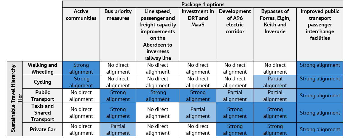
Walking and wheeling & cycling
The Active Communities option within Package 1 supports walking, wheeling and cycling - transport modes which sit at the top of the Sustainable Travel Hierarchy. This could encourage the reduced use of non-renewable energy fuelled modes of transport, supporting the decarbonisation of the transport network throughout the A96 corridor, including in and around the towns. The improved public transport passenger interchange facilities option also supports walking, wheeling and cycling as the improvements are likely to encourage the use of alternative, low carbon modes of transport.
Public transport
The options included in the public transport tier of the Sustainable Travel Hierarchy include investment in DRT and MaaS; bus priority measures; improved public transport passenger interchange facilities; and linespeed, passenger and freight capacity improvements on the Aberdeen to Inverness rail line.
Collectively, these options have the potential to improve the flow of traffic throughout the A96 corridor (including in and around the towns), increase the attractiveness of public transport and could encourage a modal shift away from private car use over time. This may contribute to a decrease in associated carbon emissions during the operation of the proposed measures, thus contributing to the Scottish Government’s net zero emissions target.
Taxis and shared transport & private car
The delivery of the bypasses is likely to improve the reliability of the A96 road corridor, and as such may make it a more attractive route for private vehicles, though by removing traffic within the bypassed towns this may also make it more attractive for residents to use the town's public transport and active travel options (aligning with the Sustainable Travel Hierarchy). As the provision of the bypasses may improve attractiveness of the A96 for private vehicles this may have a counter effect on modal shift. However, the delivery of the A96 Electric Corridor option will improve the overall network coverage and capacity for electric vehicles, which is expected to increase the overall attractiveness and reliability of using low/zero-emission vehicles along the A96. Through this option, it is expected that there will be a reduction in tailpipe carbon emissions, particularly over the long term as the uptake of low and zero-emission vehicles increases.
In the longer term, Package 1 could help to facilitate a modal shift to public transport and active travel through options such as bus priority measures and improved public transport interchange facilities for short journeys within the towns and along the A96. If this was achieved, it would support decarbonisation of the transport network in Scotland and the transition from higher to lower emission modes of transport.
Package 1 criterion 3 recommendations
All relevant design, construction and maintenance guidance, standards, processes, and assessments should be kept up to date with the latest climate change forecasts and associated best practice and applied to the development of all options.
All the options in Package 1 should be designed to maximise alignment with the Sustainable Travel Hierarchy and careful consideration should be given as to how the options can work together to optimise the lowest carbon option, for example, for different journeys and shorter routes.
As part of the Active Communities option, it is recommended that connections are maximised within the towns to improve and maximise walking, wheeling, and cycling opportunities for both local residents and visitors. Improvements could include suitable surfacing for all user types (including wheelchair users); few slopes/no stairs wherever possible; improved crossing points to promote safety; and suitably secure bike storage in and around the towns.
The impact of the options in the public transport tier of the Sustainable Travel Hierarchy on carbon emissions will depend on the fuel being used by buses and trains. It is therefore recommended that low-carbon modes of buses and trains are considered. It is envisaged that low carbon/zero carbon alternatives will become more cost efficient as technologies improve.
To fully support decarbonisation of the transport network along the A96 corridor, and in and around the towns, the following should be considered for all rail and transport hub improvement options: suitable provisions for bike storage at any improved rail station or transport hub; and improved local walking/cycling connections to promote train facilities as a suitable, sustainable mode of transport. It is important that consideration is given to how the public transport options can work together to optimise use of the lowest carbon options.
The development of the A96 Electric Corridor option could include the distribution of electric and hydrogen-based fuel sources in addition to other alternative fuels such as Hydrotreated Vegetable Oil (HVO) and Ammonia. The dispensaries should be placed strategically in and around the towns so that they are highly accessible to both road users and rural local communities. Consideration should also be given to demountable and mobile infrastructure.
The options included in Package 1 would be designed to relevant standards, such as DMRB, and therefore the design will be obligated to consider the provision of facilities for non-motorised users of the A96 corridor. The bypasses should be designed to maximise associated active travel and opportunities for public transport. It is important that consideration is given as to how the active travel and public transport options can work together to optimise use of the lowest carbon options.
Criterion 4
Criterion and success factor
Criterion 4 is:
- Extent to which the package supports the decarbonisation of the construction sector in Scotland and maximises reduction in whole life carbon emissions.
Success factor:
- 4a. Supports transition from higher emission to lower emission materials and technologies during construction, operation, and maintenance.
Geographic and environmental context
Table 5.11 below outlines the geographic and environmental context of the study area against Criterion 4 within a 7.5km boundary (unless otherwise stated, for example, when using the MET Office Data) for the towns of Nairn, Forres, Elgin, Keith and Inverurie.
| Package 1 Study Area | Geographic and Environmental Context |
|---|---|
|
Nairn |
UK Built Environment is responsible for 25% of total UK carbon emissions including buildings and infrastructure ( UK Green Building Council, 2021 ). In relation to operation of their network, Transport Scotland, as part of the Scottish Government, use renewable or zero carbon electricity tariffs for the electricity used to power the road network (such as for the use in lighting). |
|
Forres |
UK Built Environment is responsible for 25% of total UK carbon emissions including buildings and infrastructure ( UK Green Building Council, 2021 ). In relation to operation of their network, Transport Scotland, as part of the Scottish Government, use renewable or zero carbon electricity tariffs for the electricity used to power the road network (such as for the use in lighting). |
|
Elgin |
UK Built Environment is responsible for 25% of total UK carbon emissions including buildings and infrastructure ( UK Green Building Council, 2021 ). In relation to operation of their network, Transport Scotland, as part of the Scottish Government, use renewable or zero carbon electricity tariffs for the electricity used to power the road network (such as for the use in lighting). |
|
Keith |
UK Built Environment is responsible for 25% of total UK carbon emissions including buildings and infrastructure ( UK Green Building Council, 2021 ). In relation to operation of their network, Transport Scotland, as part of the Scottish Government, use renewable or zero carbon electricity tariffs for the electricity used to power the road network (such as for the use in lighting). |
|
Inverurie |
UK Built Environment is responsible for 25% of total UK carbon emissions including buildings and infrastructure ( UK Green Building Council, 2021 ). In relation to operation of their network, Transport Scotland, as part of the Scottish Government, use renewable or zero carbon electricity tariffs for the electricity used to power the road network (such as for the use in lighting). |
Package 1 criterion 4 assessment
Package 1 is at an early stage of development with limited design details on which to base an assessment. The assessment is based on potential impacts and interactions the options could have with aspects considered within this criterion.
Since there are limited design details for Package 1, the carbon emissions impact is estimated from the capital cost forecast by applying the Scottish Government ‘Supply, Use and Input-Output Tables’ figure for construction. This provides an estimate of between 140,600tCO 2 e and 280,600tCO 2 e for the capital stage carbon emissions impact.
The construction stage carbon emissions will vary between the options in the package. The variability is likely to depend on the level of new infrastructure required to implement the options – with the greater the level of construction resulting in greater levels of associated carbon emissions.
Package 1 as described makes no commitments to how the carbon emissions impact from construction, maintenance and operation would be minimised and so any resulting benefits or carbon reduction measures cannot be specifically considered within this assessment.
The operational element of the carbon emissions impact is reduced in part using renewable/zero carbon electricity tariffs, if that approach is continued.
If Package 1 is developed the options would be subject to relevant standards and assessment procedures for the type of transport infrastructure. For example, for road development this would include the Design Manual for Roads and Bridges. Where the latest version of the DMRB climate change assessment standard (LA 114) is applied it requires the assessment of carbon emissions at detailed design stage.
Package 1 criterion 4 recommendations
All relevant design, construction and maintenance guidance, standards, processes, and assessments should be kept up to date with the latest best practice on carbon emission reductions and applied to the development of all options.
If Package 1 was taken forward, there would be an opportunity as a major infrastructure project in Scotland to strongly support decarbonisation of the construction sector. Considerations of the merits of applying PAS2080: Carbon Management in Buildings and Infrastructure to schemes and suppliers has the potential to help to systematically address whole life carbon emissions. Consideration should also be given to stretching carbon emissions reduction targets for suppliers, and to the implementation of carbon neutral standards (such as PAS 2060 - Carbon Neutrality Standard and Certification) by suppliers managing the network beyond 2045.
The impact of Package 1 on carbon emissions will depend on the methods used during construction. It is therefore recommended that innovative techniques and technologies be considered for use where relevant to reduce emissions. These should be focused on optimising the design to consider the opportunities to build less and to consume less carbon intensive materials (such as asphalt, concrete and steel). Where these products are used, low carbon alternatives could be specified and sourced. For asphalt this could include lower temperature mixes, concrete with high cement replacement, and steel with high recycled content.
During construction, opportunities to reduce carbon emissions should be maximised, such as local sourcing, construction and logistics efficiencies, alternative modes of transport, for example rail rather than road, low emission vehicles, and low carbon fuels.
With regards maintenance, more resilient technology could be installed in the first instance to withstand climatic factors, subsequently making the options included in Package 1 more resilient and requiring less maintenance. As techniques and technologies improve, it is recommended that these are adopted at the earliest possible stage, subject to a cost/benefit analysis being undertaken.
The principles of the circular economy should be considered during design, construction, and maintenance. For example, material reduction and reuse should be prioritised to comply with the waste management hierarchy, and opportunities should be sought to recondition and use existing transport infrastructure where appropriate.
Criterion 5
Criterion and success factor
Criterion 5 is:
- Extent to which land use change associated with the package mitigates carbon emissions and contributes to carbon storage and sequestration.
Success factor:
- 5a. Supports the protection and development of carbon sinks, and takes appropriate measures to maximise carbon sequestration, taking account of wider ecosystem services/natural capital.
Geographic and environmental context
Table 5.12 outlines the geographic and environmental context of the study area against criterion 5 within a 7.5km boundary (unless otherwise stated, for example, when using the MET Office Data) for the town of Nairn, Forres, Elgin, Keith and Inverurie.
| Package 1 Study Area | Geographic and Environmental Study Area |
|---|---|
|
Nairn |
There are designated habitats with the potential for carbon sequestration within the study area of the package around Nairn: - Ancient woodland: 2,326 hectares. - Native Woodland Survey for Scotland: 823.50 hectares. - Peatland: Five pockets of Class 1 (nationally important carbon-rich soils, deep peat and priority peatland habitat) and seven pockets of Class 3 (dominant vegetation cover is not priority peatland habitat but is associated with wet and acidic type). - Local Landscape Area: The Sutors of Cromarty, Rosemarkie and Fort George LLA to the north-west of Nairn feature an array of coastal farmlands, as well as beaches, dunes and links. |
|
Forres |
There are designated habitats with the potential for carbon sequestration within the study area of the package around Forres: - Ancient woodland: 4,679.26 hectares. - Native Woodland Survey for Scotland: 1,242.32 hectares. - Peatland: Three pockets of Class 1 (nationally important carbon-rich soils, deep peat and priority peatland habitat), one pocket of Class 2 (nationally important carbon-rich soils, deep peat and priority peatland habitat) and 18 pockets of Class 3 (dominant vegetation cover is not priority peatland habitat but is associated with wet and acidic type). - Local Landscape Area: The Culbin to Burghead Coast LLA to the north of Forres features an array of expansive coastal farmlands, moorland hills and broadleaf woodlands. |
|
Elgin |
There are designated habitats with the potential for carbon sequestration within the study area of the package around Elgin: - Ancient woodland: 1,939.43 hectares. - Native Woodland Survey for Scotland: 650.77 hectares. - Peatland: Two pockets of Class 1 (nationally important carbon-rich soils, deep peat and priority peatland habitat) and four pockets of Class 3 (dominant vegetation cover is associated with wet and acidic type). - Local Landscape Area: The Spynie LLA within the north of the Elgin study area features a rich array of wetlands, loch, woodlands and farmland. |
|
Keith |
There are designated habitats with the potential for carbon sequestration within the study area of the package around Keith: - Ancient woodland: 1,572.18 hectares. - Native Woodland Survey for Scotland: 834.23 hectares. - Peatland: 19 pockets of Class 1 (nationally important carbon-rich soils, deep peat and priority peatland habitat) and 43 pockets of Class 3 (dominant vegetation cover is not priority peatland habitat but is associated with wet and acidic type). - Local Landscape Area: The Deveron Valley LLA to the south-east of Keith features a rich array of farmed and wooded river valleys that form a significant feature within the extensive agricultural heartlands of Moray. |
|
Inverurie |
There are designated habitats with the potential for carbon sequestration within the study area of the package around Inverurie: - Ancient woodland: 1,429.77 hectares. - Native Woodland Survey for Scotland: 1,179.65 hectares. - Peatland: Three pockets of Class 1 (nationally important carbon-rich soils, deep peat and priority peatland habitat) and one pocket of Class 3 (dominant vegetation cover is not priority peatland habitat but is associated with wet and acidic type). - Local Landscape Area (LLA): The Bennachie LLA to the west of Inverurie features a rich array of woodlands, heather moorland and numerous historic features including an Iron Age hill fort at the summit of Mither Tap, Barmykyn Hill fort on Airlie Hill and cairns on other summits. |
Package 1 criterion 5 assessment
Package 1 is at an early stage of development with limited design details on which to base an assessment. The assessment is based on potential impacts and interactions the options could have with aspects considered within this criterion.
The transport options within Package 1 are solely infrastructure-led and do not explicitly include the provision of public realm improvements to green space or blue or green infrastructure assets. Therefore, it is not possible to confirm if Package 1 would have a positive impact on land use change, carbon storage and sequestration.
Package 1 will likely have a negative environmental effect on the storage and sequestration of carbon within natural ecosystems, particularly resulting from the bypasses of Forres, Elgin, Keith and Inverurie. However, due to limited design information the extent of any effect is uncertain.
The options included in Package 1 would be developed in accordance with the relevant standards including DMRB and relevant Scottish Government and Transport Scotland policies and plans. The scale of the effects would be subject to detailed design and the location of the options being determined.
Package 1 criterion 5 recommendations
All relevant design, construction and maintenance guidance, standards, processes, and assessments should be kept up to date with the latest climate change forecasts and associated best practice and applied to the development of all options.
Consideration should be made during the site selection process to prioritise locations where there are likely to be minimal potential adverse effects on natural capital, carbon storage and sequestration.
Existing carbon sinks should be enhanced wherever possible, to increase potential carbon sequestration as an integral part of the schemes, p articularly relating to peatland restoration and wetland enhancement.