Texture measurements
Manual Volumetric Patch Test (VPT)
This simple volumetric measurement technique consists of spreading a known volume of material on the surface of a pavement and measuring the area covered. The mean texture depth is then calculated by dividing the volume by the area. Originally sand was used but this has been replaced by glass spheres which have a more regular shape. The main advantage of the test method is that it is simple to carry out. However, limitations include the fact that the test is carried out over a relatively short section of the pavement and may not be representative of the entire paved surface. In addition, it is a slow process and potentially dangerous as it requires technicians to work near live traffic.
Traffic speed condition surveys
Over the last 30 years, traffic speed condition surveys have been developed to collect information up to 100 km/h. The vehicles are equipped with lasers, video image collection, inertial and GPS apparatus. In Scotland, traffic-speed surveys are carried out using the Surface Condition Assessment of the National Network of Roads (SCANNER).
SCANNER surveys
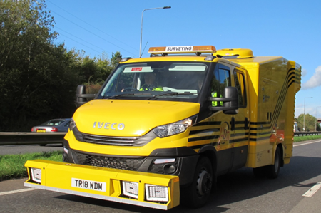
Transport Scotland commission annual SCANNER surveys of their network. WDM are the current survey contractor and condition data is collected from Lane 1 of the Trunk Road network using their Road Assessment Vehicle (RAV), which is shown in Figure 2-1. This accredited SCANNER survey vehicle collects images and laser profile data and the raw data is converted into a range of condition parameters including texture depth.

Laser-based texture indicators
Both SMTD and MPD are indicators of texture depth along the length of a pavement. This section provides some background information on how they are calculated from raw laser-based measurements and how the relationship between the two is complex.
Collection of SMTD and MPD
As stated in the introduction, SMTD is currently used in the UK to monitor the texture of in-service pavements and is used to define various condition categories in terms of deterioration. Although available as an output from laser-based surveys, MPD is not generally used but it is recognised as the most commonly applied measure of texture depth internationally.
Both measurements are based on laser-based profile data that is collected in a single line located in the nearside wheelpath. In addition, it should be noted that many systems are also capable of measuring in the centre of the lane and the offside wheelpath. Research is ongoing to determine whether the latter can be used to identify defects associated with general road surface deterioration.
As the vehicle moves along the road the sensors measure changes in vertical height to the road surface, due to the surface texture. Measurements are recorded at short intervals, typically 1mm spacing. However, the raw data requires to be processed and filtered dependent on the required means of reporting. The different algorithms used to calculate SMTD and MPD are described below.
Processing SMTD and MPD
Prior to reporting SMTD or MPD, algorithms are used to process the laser measurements collected by the survey vehicle. Processing of the data typically includes the following:
- Evaluation over calculation length
- Data is split into 300mm lengths for SMTD and 100mm for MPD.
- Filtering
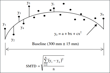
- A best-fit parabolic trend curve is applied to each 300 mm SMTD evaluation length.
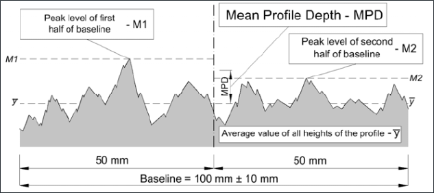
- The slope of each 100mm MPD segment is suppressed by subtracting a linear regression of the segment, providing a zero mean profile.
- Height calculation
- The standard deviation is calculated using the deviations of the texture profile from
the SMTD trend curve (see Figure 2-2).
- The height is determined as the arithmetically averaged two peak levels minus the average MPD profile level (see Figure 2-3).
- Aggregation to longer length
- In both cases the average texture height for all evaluation lengths within each 10m length are calculated.


Differences between SMTD and MPD
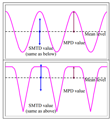
The difference between the two measures is in the way the height of the texture is estimated, with the SMTD comprising a root mean square measure and the MPD a measure of the highest peak above the mean level. It has been reported that the two measures are influenced by the type of road surface, particularly the shape of the surface and this is illustrated in Figure 2-4. The figure contains two hypothetical surface shapes: the top surface has sharp peaks and the bottom surface has more rounded and flatter peaks. The figure illustrates that the SMTD may be quite different from the MPD.
